Hó- és zivatarlesen
Sat24 animált mûholdkép
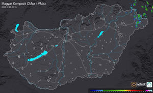
Európai radarképek
Kedves fórumozók!
Egy újabb fejlesztés nyomán az alábbi változás állt be a szakmai fórumok használatával kapcsolatban: A "Hó- és zivatarlesen" valamint a "Hosszútávú esélylatolgatások" fórumok használata ezentúl az ú.n. szakmai joghoz van kötve.
Részleteket ld. a Metnet szabályzat I/7. pontjában.
Módosítva: 2009.07.18

...Slovakia, Hungary, Austria, northern Italy...
Higher CAPE is forecast over Hungary, while the good deep layer shear is only touching upon the western edge of the tongue of unstable air. Still more than 15 m/s deep layer shear and >100 m2/s2 SREH is forecast to be present, and abundant convective precipitation signals. Long-lived multicells, perhaps isolated cases tending to become supercells can be expected with a large hail chance, especially near Hungary where there is a bit more CAPE to work with, but the lee of the Alps may also see isolated hail.
forrás: ESTOFEX
Tetszik
Havazás előrejelzés

Utolsó észlelés
Térképek
Radar
Aktuális hõmérséklet
Aktuális szél
Utolsó kép

Feketén fehéren a karácsonyról
Időjárás-változás | 2025-12-21 10:00
Szabályzat