Hó- és zivatarlesen
Sat24 animált mûholdkép
Európai radarképek
Kedves fórumozók!
Egy újabb fejlesztés nyomán az alábbi változás állt be a szakmai fórumok használatával kapcsolatban: A "Hó- és zivatarlesen" valamint a "Hosszútávú esélylatolgatások" fórumok használata ezentúl az ú.n. szakmai joghoz van kötve.
Részleteket ld. a Metnet szabályzat I/7. pontjában.
Módosítva: 2009.07.18
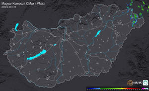
Estofex:
A cluster of storms should develop and move towards the NE, crossing Hungary and possibly the eastern parts of Austria after 00Z. Instability is on the decrease but moderate DLS ( especially enhanced at lowest 3km ) will be enough for multicell storms with a mostly marginal hail / gusty wind threat.
Cells over southern / eastern Hungary could profit of enhanced SRH with an enhanced hail threat.
No level was introduced right now, but a small level 1 over parts of Hungary could become necessary later on.
Szóval megint késõ este várható az akció.
Utolsó észlelés
Térképek
Radar
Aktuális hõmérséklet
Aktuális szél
Utolsó kép

Érdekességek | 2026-03-27 16:50
Szabályzat